Reduces the cost and time of exploration.
Proprietary Technology
CAGE-IN
Constrained Area Gridding for Enhanced Interpretation
1
Data Acquisition
2
Structural Analysis
3
Grade Estimation
4
Integration
5
Compliant Report
What It Is
What is CAGE-IN?
CAGE-IN stands for "Constrained Area Gridding for Enhanced Interpretation". It is our proprietary technology for integrating geological and geophysical data to generate better insights using the same traditional data with the help of AI.
CAGE-IN Components:
-
Enhances unconstrained contrast of a geophysical dataset to highlight subtle anomalies.
-
Imposes geological criteria on the geophysical data and forces processing of geophysical data strictly within the geological constraints. This prevents distortion of geophysical grids by data from different geological domains and improves spatial precision of geophysical anomalies.
-
Defines the geological targets in terms of relational geophysical databases and uses multiple geophysical properties to scan a large area and define locations of potential metal deposits.
The Case for CAGE-IN
Why Use CAGE-IN?
Identifies potential metal deposits that would otherwise be missed.
Helps to meet the growing demand for base metals, precious metals and battery metals.
Where It Works
From Porphyry Copper to Graphite
Rooted in theoretical geology, CAGE-IN is commodity-agnostic and built to adapt to any geological environment. Its track record already spans the world's most economically significant deposit types.
Porphyry Cu-Au
Applied & validated
Skarn Au-Ag
Applied & validated
Epithermal Au
Applied & validated
Ni Laterite
Applied & validated
Orogenic Gold
Applied & validated
Intrusive-Related
Applied & validated
Graphite
Applied & validated
New Settings
Under active testing
Not sure if CAGE-IN applies to your deposit type? Ask us directly →
Financial Impact
CAGE-IN Helps Save Costs Across Several Dimensions
- Time Efficient
- By using CAGE-IN the early exploration cycle is shortened from up to 3 years to under 3 months.
- Optimized Exploration
- The AI-based algorithm makes recommendations on what additional data would be beneficial to pin-pointing the resource.
- Risk Mitigation
- With quicker results, projects with lower valuations can be sifted through faster, reducing financial risk of wasted investment.
- Enhanced Valuation
- By finding more potential in an existing area, CAGE-IN can help increase your project's valuation without any additional land or data.
- Cost Effective
- Save money in multiple ways: less time in early stages, less waste in unnecessary exploration work, identification of total potential value, and maximization of that valuation with the least possible investment.
- Environmental Protection
- Targeted footprint means less places to visit, less samples, less line cutting, less drill pads and access roads. Up to 40% lower environmental footprint of exploration.
For Geophysicists & Survey Partners
Technical Specifications
Everything your technical team needs to evaluate CAGE-IN for integration into your survey workflow.
Accepted Input Data Types +
CAGE-IN is geophysical-method agnostic. Any dataset that can be expressed as gridded or point values can be processed, including:
- → Magnetics / TMI (X, Y, Z components)
- → Radiometrics (Total Count, U, Th, K)
- → Gravity
- → IP / Resistivity
- → EM (Time-domain and Frequency-domain)
- → MT (Magnetotellurics)
- → Satellite / Remote Sensing imagery
- → Geological maps and structural data
- → Geochemistry (soil, rock, drill hole)
- → Historical artisanal workings / known mineralisation
Input Format & Resolution Requirements +
CAGE-IN accepts data in any of the following standard geophysical formats:
- →CSV / XYZ point files (X, Y, value columns)
- →Geosoft XYZ format
- →Geosoft .grd grid files
- →ASCII grid files
Grid spacing / scale: Any grid spacing or survey scale can be used — from regional reconnaissance to detailed deposit-scale grids. No minimum or maximum resolution is required; CAGE-IN adapts its processing to the data provided.
Output Deliverables +
Clients receive a complete interpretation package:
- →Enhanced geophysical maps showing CAGE-IN-processed datasets
- →Potential target areas with correlation analysis
- →Target point files for drill planning
- →Confidence classification of identified targets
- →Written interpretation report with geological context and recommendations
Output Formats & Software Compatibility +
All deliverables are provided in open GIS-compatible formats:
- →.shp — Shapefile (vector targets, polygons)
- →.gpkg — GeoPackage (preferred open format)
- →.tif / .tiff — GeoTIFF (raster maps and enhanced grids)
These formats load natively into Oasis Montaj, ArcGIS, QGIS, Leapfrog, Micromine, GOCAD/SKUA, and any other GIS or geological modelling platform that supports standard vector/raster formats.
IP & Technology Protection +
Innovation Protected. Guarded Code. Unguarded Potential.
We openly share the conceptual framework of CAGE-IN — its inputs, outputs, and the geological logic behind it. The actual working code and processing flowsheets are closely guarded as a company trade secret. We deliberately choose not to patent CAGE-IN in order to avoid public disclosure of our proprietary algorithms.
This means the processing power CAGE-IN brings to your projects remains exclusively in our hands — and exclusively yours to benefit from.
Data Security & Confidentiality +
Your exploration data is your company's greatest asset. We treat it accordingly:
- →Mandatory Mutual NDA before any data is shared
- →All client data stored on corporate enterprise Dropbox — AES-256 encryption in transit and at rest
- →Access restricted on a strict need-to-know basis to team members assigned to your project
- →Client data is never co-mingled with other project data
- →Data retained only for the duration of the engagement unless otherwise agreed
Collaboration Model
How We Work With Your Team
CAGE-IN augments your in-house geological team — it does not replace it. Here is exactly how a typical engagement unfolds, from first contact to final deliverable.
- 01~2 working days
Mutual NDA & Scoping Call
We begin with a mutual NDA and a scoping call with your geo team to understand your data inventory, project stage, and key geological questions. No data changes hands until this step is complete.
- 021–3 days
Data Handover & Quality Assessment
You share datasets via our secure enterprise Dropbox environment. We assess data quality, identify any preprocessing requirements, and confirm a firm delivery date.
- 032–8 weeks
CAGE-IN Processing
Our team processes your geophysical, geological, geochemical, and remote sensing data through the CAGE-IN workflow. Your team is not required to contribute time at this stage — we work independently.
- 041 week
Draft Target Review With Your Geo Team
We present draft targets and preliminary interpretations to your geo team in a working session. Your team's project knowledge informs revisions to target ranking and geological interpretation before finalisation.
- 05On confirmed date
Final Report Delivery
We deliver the complete CAGE-IN report with all GIS-compatible data files, target coordinates, confidence classifications, and the written interpretation — structured to provide your QP with everything needed for compliant disclosure.
- 06As needed
Optional: Ongoing Support & Retainer
Retainer arrangements are available for iterative re-processing as new drill data comes in. QP sign-off support and news-release technical review are available as optional add-on services.
Government & Jurisdictional Programs
National-Scale Prospectivity Mapping
CAGE-IN scales from a single exploration licence to an entire national territory. For governments, geological surveys, and ministries of natural resources, AIRE deploys the same methodology across jurisdictions of 100,000 km² and beyond — converting existing national datasets into a ranked, investor-ready mineral intelligence system without requiring new data acquisition.
What CAGE-IN Needs at National Scale
- →National aeromagnetic and radiometric (K, U, Th) coverage — 100% aero-geophysical is sufficient to begin
- →Landsat, Sentinel-2, and ASTER remote sensing for alteration and structural lineament mapping
- →Existing geological maps for domain definition and constraint setup
- →Legacy exploration reports, drill databases, and mineral occurrence records
- →Geochemical data integrated as a weighted supplementary variable where available — not a prerequisite
What You Receive
- →200+ probability-ranked mineral targets across priority commodity groups
- →National digital mineral atlas — integrated GIS platform, fully operational in QGIS
- →Investor prospect sheets for international conferences (PDAC, Mining Indaba)
- →Geochemical survey prioritisation maps directing field teams to highest-probability zones
- →Embedded training for 5–10 government geoscientists to independent operational competency
Data Sovereignty
All outputs vest exclusively in the government client from moment of acceptance. No ongoing license fee, subscription, or vendor dependency of any kind.
Open Formats
All deliverables in SHP, GPKG, GeoTIFF, and other non-proprietary formats — compatible with QGIS, ArcGIS, and all industry-standard systems.
Results-as-a-Service
Payment only on accepted, verified deliverables approved by the client's technical authority. AIRE bears all processing risk until acceptance.
Standards Compliant
Outputs natively support NI 43-101, JORC, UNFC, CRIRSCO, and ECOWAS mineral policy frameworks.
Typical Program Structure
Phase 1
Mobilisation & Data Compilation
Months 1–5
GIS database architecture, data quality assessment, geological domain definition, and block prioritisation confirmed with the geological survey.
Phase 2
Block-by-Block Processing
Months 4–41
Sequential CAGE-IN processing of all geographic blocks with parallel capacity building. Payment per accepted block prospectivity map.
Phase 3
Marketing & System Handover
Months 39–42
National investment prospectus, prospect sheets, GIS investor package, conference materials. Full platform handover to trained government staff.
Base timeline 42 months for national coverage; acceleration to 24–30 months available with parallel block processing. Program scope confirmed at inception.
Speed Without Compromise
From Raw Data to Drill Targets: How Fast?
We value speed as much as precision, delivering your complete CAGE-IN prospectivity mapping report within two to eight weeks per prospect area. This flexible timeline depends directly on your data's readiness, the geological complexity of the site, and whether you require a 2D or fully immersive 3D mapping solution.
We work closely with your team during the onboarding phase to assess your data and provide a firm, reliable delivery date — ensuring your exploration timeline stays on track without ever sacrificing the quality of your targets.
Single prospect area — 2D
Processed grid data ready to ingest
Multi-prospect or regional — 2D
Depends on data volume and geological complexity
Full 3D prospectivity mapping
Includes structural and lithological modelling layers
Data digitisation required
If raw data requires preprocessing before ingest
Timeline confirmed during onboarding assessment. Rush delivery available on request.
For Listed Companies
Regulatory Compatibility & QP Sign-Off
We know that regulatory compliance is a non-negotiable deal-breaker for listed companies. Here is exactly how CAGE-IN fits into your disclosure workflow.
Your QP or Ours
Our reports are packed with robust geological and mathematical detail that your internal Qualified Person (QP) or Competent Person (CP) can use directly as input for their own NI 43-101 or JORC reporting. If you need a full turnkey solution, we have QP-credentialed reporting geologists who can provide compliant sign-offs as an optional add-on service.
View a sample CAGE-IN reportThe Math That Makes Your QP's Job Easier
CAGE-IN is a fully defensible exploration targeting technology rooted in theoretical geology and robust mathematical rationale. It generates high-confidence drilling targets based on your existing data, but does not make grade or resource statements. Once initial drilling confirms the model's consistency, CAGE-IN's advanced mathematics can be used to establish a statistical rationale for the "continuation of mineralisation" — empowering your QP to achieve higher-confidence reporting categories while requiring significantly less infill drilling.
What this means for your news release: CAGE-IN-derived targets are geological interpretation outputs — the same category as any third-party geophysical interpretation report. Your QP reviews and signs off on them before public disclosure, exactly as they would with any exploration target. We provide the technical detail and mathematical justification they need to do that efficiently.
Investment
Pricing Scoped to Your Project
Because no two exploration targets are identical, we don't believe in rigid, one-size-fits-all pricing. Our project-specific fees scale dynamically with your project's unique scope — factoring in total area size, data volume, digitisation requirements, and whether you need 2D or 3D mapping.
- → Fees scale with area size, data volume, and geological complexity
- → Steeply discounted rates for long-term retainer arrangements
- → White-label and co-branded delivery available for survey companies
- → 2D and 3D mapping priced separately — you pay only for what you need
Get a Quote in 2 Working Days
Provide us with a few details about your project and we will get back to you with a project-specific quote — no commitment required.
Request a QuotePrefer to Talk First?
Book a free 30-minute consultation with Dr. Amit Tripathi — no commitment, no sales pitch, just an honest conversation about your project and whether CAGE-IN is a fit.
Schedule a Free 30-Min CallTechnical Transparency
The One Thing Every "Magical" AI Tool Tries to Hide
At our core, we believe a truly credible tool openly acknowledges its limits. CAGE-IN is fundamentally driven by the data on which it is based — the higher the resolution and quality of your input data, the more precise our interpretations become.
To maintain absolute technical integrity, every CAGE-IN report we deliver clearly defines the specific limitations of that interpretation and provides the necessary cautions for the reader. You will never receive a report that oversells certainty.
Review a sample CAGE-IN report — including the Limitations sectionWhat We Always Document in Every Report
→
Data Resolution Constraints
We specify the resolution of every input dataset and its impact on target confidence and minimum detectable anomaly size.
→
Coverage Gaps
Areas with single-dataset coverage or no coverage are mapped and flagged — targets in these zones carry a lower confidence tier.
→
Geological Uncertainty
Where multiple geological models are plausible, we present each and explain how drilling can discriminate between them.
→
Recommended Verification Steps
Every target includes a recommended next step — from low-cost geochemical sampling to scout drilling — proportional to the target's confidence tier.
What You Receive
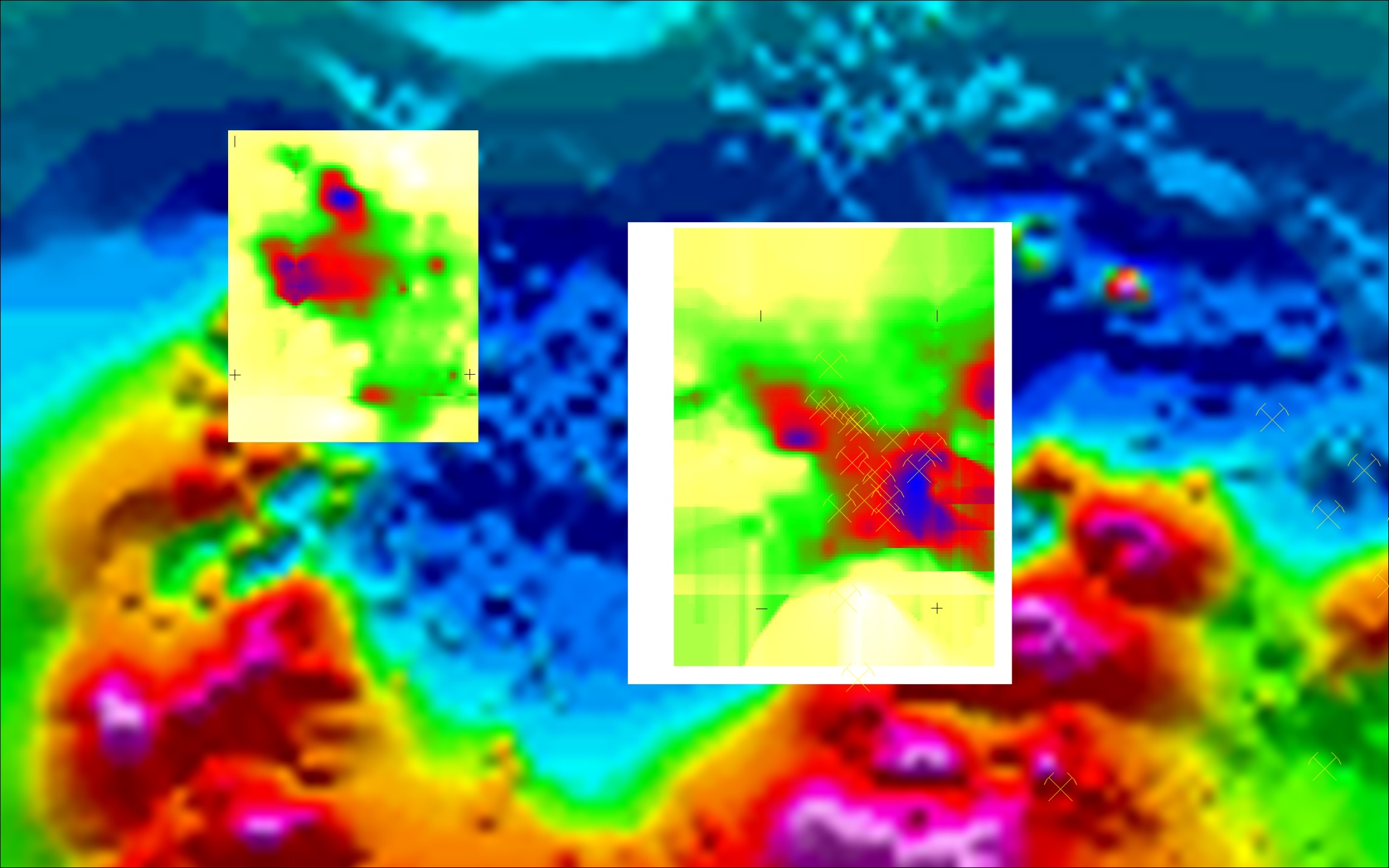
Sample CAGE-IN Outputs
Real results from completed projects — all anonymised. These images show typical CAGE-IN deliverables: enhanced geophysical maps with new targets identified against known mineralisation.
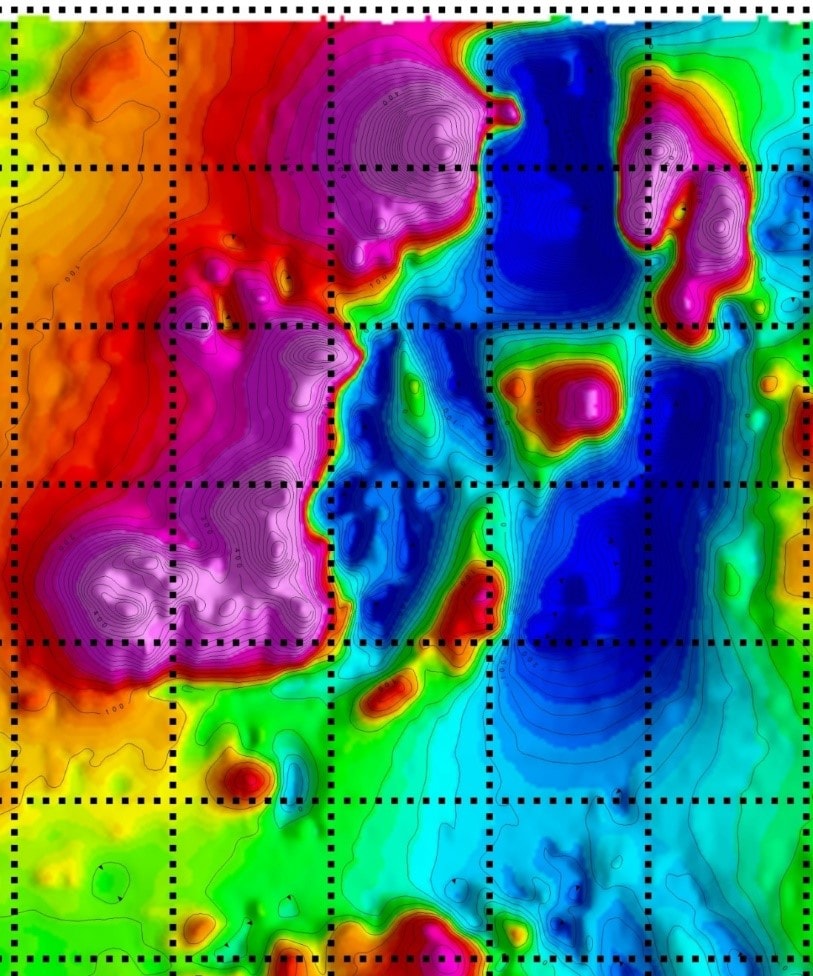
Before: Standard TMI — Skarn Deposit
Conventional processing — known mineralisation only visible
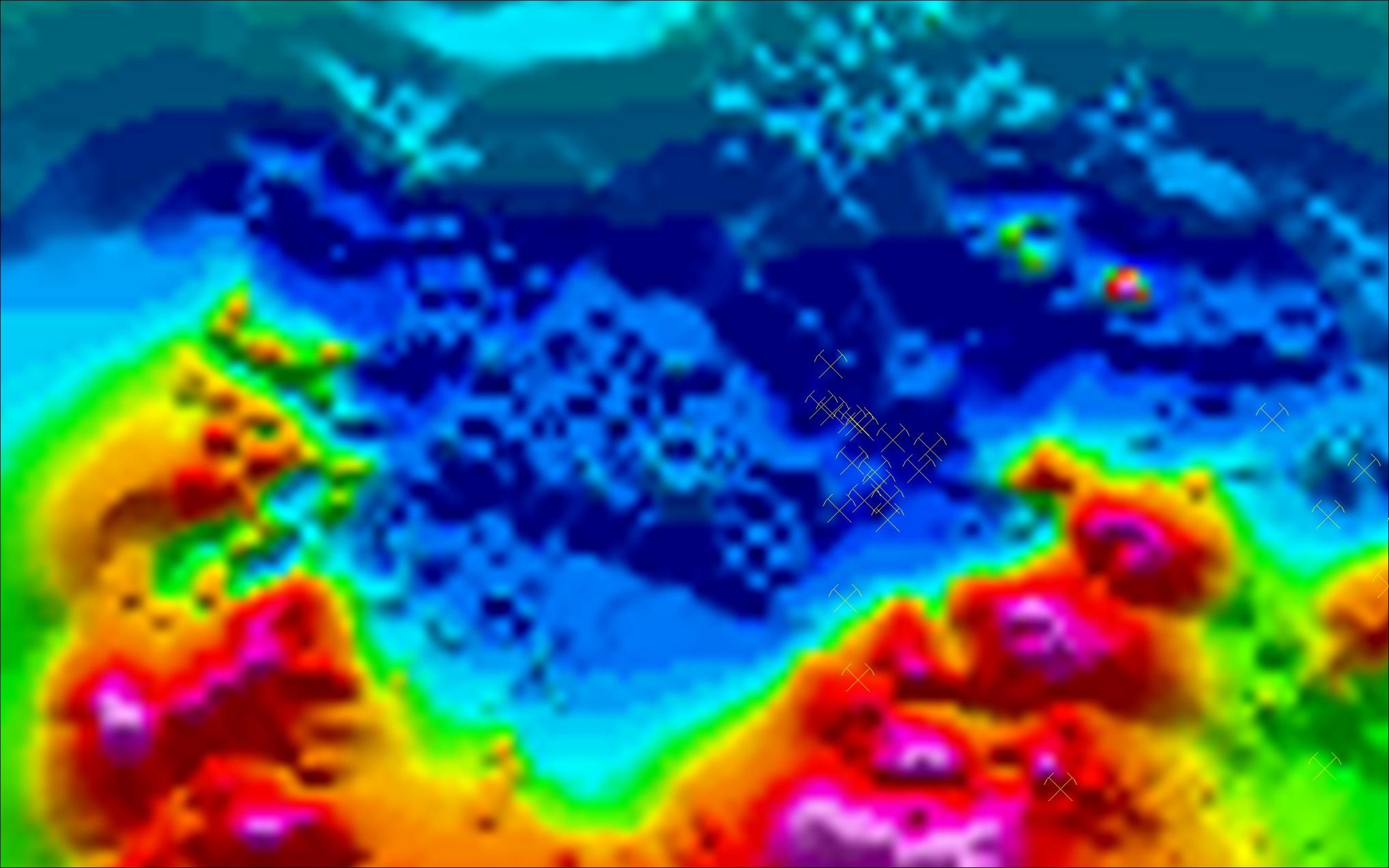
After: CAGE-IN Enhanced TMI — New Targets Identified
CAGE-IN processing reveals additional mineralised zones
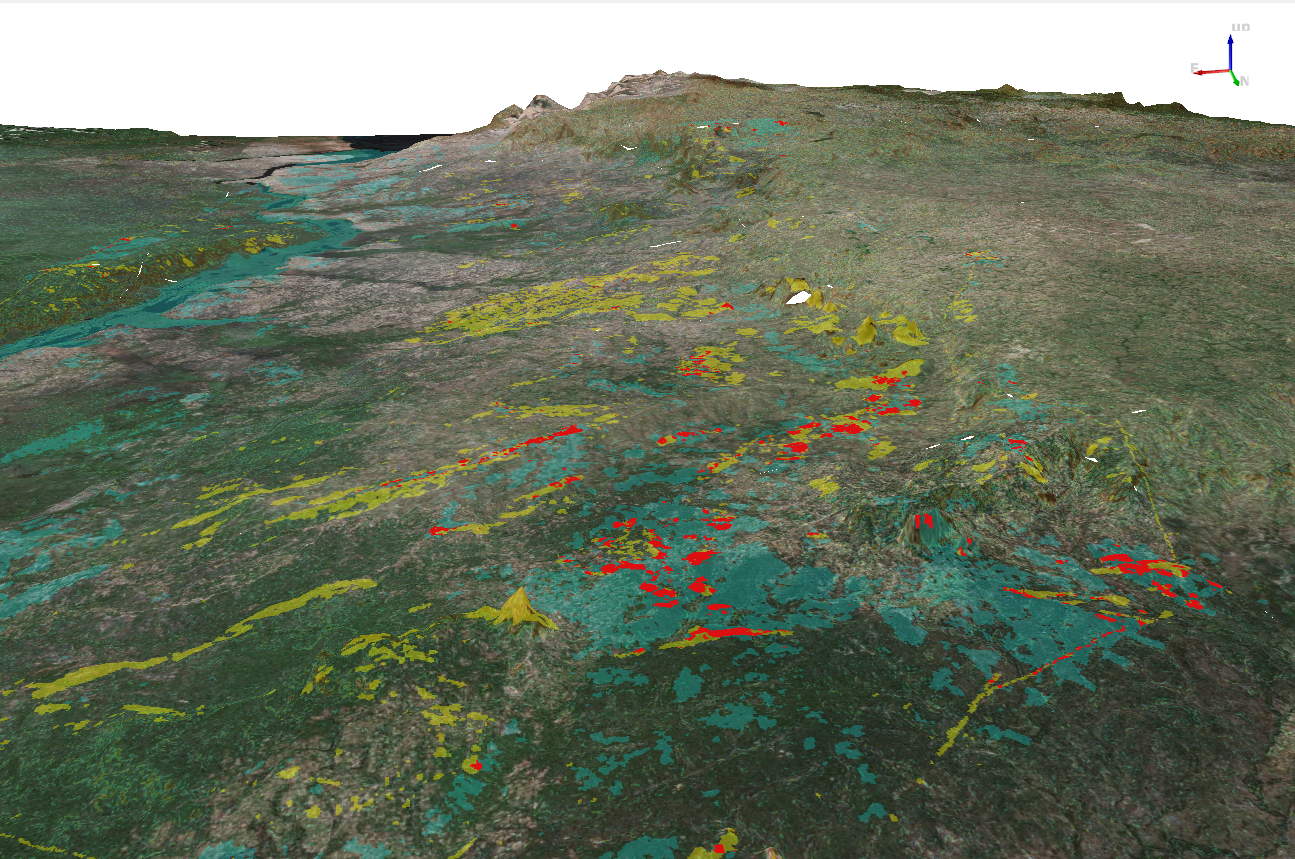
Greenfield Discovery: Ni Laterite Targets — East Africa
CAGE-IN applied to aerogeophysics, remote sensing, topography, lithology and geomorphology — Ni resources taken from greenfield to resource in 2 years
For Survey Companies
Add CAGE-IN to Your Survey Offering
Stop paying for interpretation technology you only need part of the time. CAGE-IN is available to geophysical survey companies as a value-add interpretation layer — delivered on a flexible, project-specific fee model that scales directly with your project's scope.
- →Pricing scales with survey area size, geological complexity, and data volume
- →Steeply discounted rates for long-term retainer arrangements
- →White-label or co-branded delivery available
- →Custom response within 2 working days of inquiry
Data protection guaranteed. All inquiries are covered by our standard Mutual NDA and data security protocols before any project data changes hands.
Request a Project-Specific Quote
Tell us what you need — we'll get back to you with a tailored offer within 2 working days.
See It In Action
Ready to Explore With CAGE-IN?
Review our case studies to see real-world results, or get in touch to discuss how CAGE-IN can be applied to your project.